


If you want “a café with seats near a landmark” and you do not have an exact shop name, an ordinary map often makes you search for the landmark first, then tap nearby places one by one. On November 21, 2026, in desktop Chrome, we opened hippomaps. We did not create an account, and we did not grant location permission. We typed a few searches in plain language, checked the pins against places we already knew, and then tried walking, driving, and public transit.
When it opened, the page title was “hippomaps – search the map in plain words,” and the interface was in English. On the left is a search box; on the right is an OpenStreetMap basemap, with overpass.ch and © OpenStreetMap in the lower left. We did not see a cookie banner, a login wall, or a pop-up ad. The menu lets you change the map style (Day and night, Light, Dark, Outdoor, Relief, Driving) and turn on 3D buildings, terrain, traffic, or transit lines. Language is split into “page and map” and “routes and voice.” For the page and map, the only options are Automatic, Deutsch, English, Français, and Italiano; there is no Chinese interface, and the voice list has no Chinese either. At the bottom of the menu there is a donation bar in Swiss francs. We did not donate.
We did not click “show my location.” The browser’s location permission stayed on “not yet decided,” and no location dialog appeared. The map itself landed around Zhengzhou, in central China (about 34.747°N, 113.625°E, zoom 11), and the examples in the search box also mentioned the Jinshui River and Zhengzhou. The site’s privacy page says that when the page opens, the server looks up an approximate town from the IP in a local database, and the map stays there until the device provides a location. We did not separately check which city this egress IP should count as, so we only recorded the center point we actually saw, and we are not treating it as proof that the site already knew a precise city.
Who it is for, and how to ask in one sentence
It is a good fit if you want to query OpenStreetMap in one plain sentence — what kind of place, near which landmark — without signing up first. It is not a navigation device, and it is not a local review site: whether there are photos or opening hours depends on that OpenStreetMap record and on what the site can fetch. If you already have a track file and want to convert it to GPX or KML in the browser, we have written about GPX Converter. That is file conversion, not searching for nearby shops in a sentence.
The usage is straightforward:
- Open https://hippomaps.ch/, with no login required.
- Type a sentence in English, or an English category plus a place name, for example
cafes near Baotu Spring in Jinanorcafes near 趵突泉(Baotu Spring, a well-known spring park in Jinan, in eastern China). Then search. - First check how the sentence was understood (a summary such as “Cafe, within 1 km of Baotu Spring (north) in Jinan”), then compare the list with the pins on the map. Open a shop and see whether an address, opening hours, and photos are there.
- For a route, click Directions next to the search box, fill in a start and an end, and choose Car, Bike, Walk, or Transit. Do not look only at the default driving result.
Please do not test this with your home address or a daily commute. The examples below are all public landmarks.
What our searches actually returned, and whether the pins were right
The test was on November 21, 2026, in desktop Chrome, while we were signed out and had not granted location access.
After cafes near Baotu Spring in Jinan, the map jumped to about 36.6631°N, 117.0103°E, at a zoom of about 15.2. The summary was cafés within 1 km north of Baotu Spring in Jinan. It listed 11 places, including Maan Coffee, Zoo Coffee, Starbucks, Meiri Beixiang, Heytea, Mixue Ice Cream & Tea, Xiaoshuo Coffee, % Arabica, and M Stand. (Heytea and Mixue are large Chinese tea and dessert chains; Mixue appearing under “cafes” is how this query’s results were labeled.) Baotu Spring Park was visible on the map, and the pins fell around the park, which matches the known location of the spring. In the list, Mixue was then marked Closed · opens 09:00.
A full Chinese sentence, 济南趵突泉附近的咖啡馆 (“cafés near Baotu Spring in Jinan”), was not accepted: the interface returned an error, and the page showed in red, Nothing called “济南趵突泉附近的咖啡馆” was found, with a suggestion to use “what in place,” for example “cafés in Bern.” Changing it to cafes near 趵突泉 worked, again with 11 results, and the map center still on Baotu Spring. cafes in Jinan (the English city name) was read as the administrative area of Jinan in Shandong, returning 64 results, and it noted that there is also a place of the same name in Jeollabuk-do, South Korea. But cafes in 济南 treated “济南” as a point (about 36.66891°N, 116.98531°E) and found only 1 result within 1 km. For the same city, the Chinese name and the English name are not understood the same way. You cannot assume that a Chinese sentence will work.
For a second Chinese city we used Shanghai Railway Station. hospitals near Shanghai Railway Station placed the map correctly on the station (about 31.249°N, 121.451°E), and the outline of the station building was also right, but “Hospital Grounds within 500 m of the station” returned 0 results. The page said OpenStreetMap may use different tags here. Changing the search to cafes near Shanghai Railway Station produced 16 results at the same location. The list and pins included Starbucks, Luckin Coffee (a Chinese coffee chain), Kafeina (then marked Open · closes 22:00), Wagas, and others, and the station position was still correct.
In Europe we used pharmacy near Zürich Hauptbahnhof. The map center was about 47.37744°N, 8.53904°E, around Zurich’s main station, and it returned 25 pharmacies, with street numbers and opening hours.
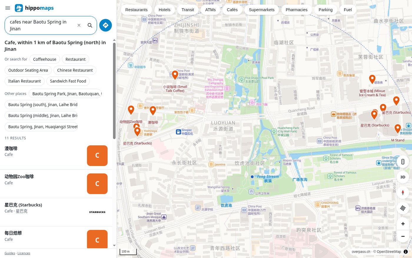
Opening “漫咖啡” (Maan Coffee) in the Jinan results moved the map to about 36.663743°N, 117.002966°E, roughly a kilometer west of Baotu Spring, which matches the “within 1 km” summary. The place page had only the name, Cafe, Directions / Save / Share, and OSM tags such as amenity=cafe. There were no photos and no opening hours. The same day, opening “Baotu Spring Park, Jinan” centered on about 36.66134°N, 117.009765°E; the park outline and the names of springs inside the park were there, and the position matched the known spring. That entry also had almost no photos.
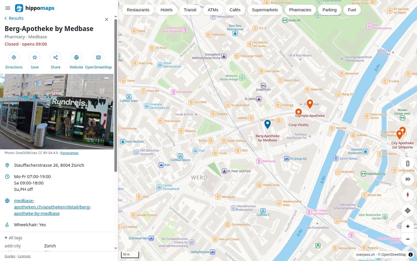
Berg-Apotheke by Medbase in the Zurich list was much more complete. The pin was about 47.373173°N, 8.52932°E, about 1 km southwest of the main station. The page had a street-level photo (credited Photo: OneOSMUser, CC BY-SA 4.0 · Panoramax), the address Stauffacherstrasse 26, 8004 Zürich, opening hours Mo-Fr 07:00-19:00, Sa 09:00-18:00, Su,PH off, a status then of Closed · opens 09:00, plus a website and Wheelchair: Yes. So what a place page can show depends on how complete that record is. You cannot take this one Jinan café as the rule, and you cannot take this one Zurich pharmacy as the rule either.
If what you want is not a café or a pharmacy, but whether a place has had public satellite imagery in the past week, that is a different kind of public geographic information. We have written about Watched.earth.
What the routes and public transit actually produced
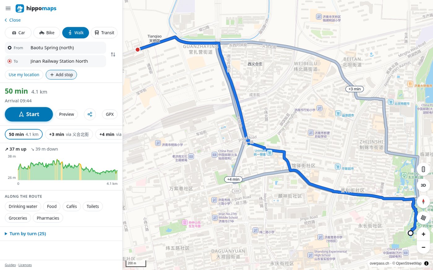
The Directions panel defaults to Car, with Bike, Walk, and Transit as well. The start field first said Your location; we had not granted location access, so we replaced it with place names and clicked the suggestions. For the Jinan route, the suggested start was “Baotu Spring (north),” and the suggested end was “Jinan Railway Station North” (the north side of the station, not the middle of the building).
The default driving result was 7 minutes and 5.9 km, with alternatives via Jingliu Road, G309, and Shunhe East Street. That looks like a driving detour, and it should not be treated as a walking time. After we clicked Walk, the same pair became 50 minutes and 4.1 km, with elevation: 37 m up and 39 m down, plus two slightly longer walking alternatives. The route went west from the Baotu Spring area, then north to Jinan Railway Station North, which looks plausible. Bike was 18 minutes and 5.1 km.
After we clicked Transit, a request went to the trip interface and returned 404. The page said: No public transport stop near the start. Timetables: Europe. This Jinan query did not produce a schedule.
In Zurich, walking from Zürich Hauptbahnhof to Kunsthaus Zürich (the suggestion was Kunsthaus, Heimplatz 1) was 16 minutes and 1.3 km, through the city center, and the distance is plausible. For the same pair, under Transit and Leave now, it offered several night routes, for example an N5 from 01:58–02:09, 11 minutes in total, with two walking segments and one tram, and the line on the map plus the walking dashes lined up with the two places. The browser’s time zone at the time was mid-morning in Beijing, and the clock times on the page were around 2 a.m. local time in Zurich. The same day, when we changed the destination to Zürich Airport (the suggestion landed on Fromattweg), Transit returned “No connection found at this time. Timetables: Europe.”, and walking returned “No route between these points.” European public transit can work, but not every pair of points, and not every destination name, will produce a schedule. Chinese cities were clearly outside the timetable coverage in this test.
After we changed “page and map” from Automatic to Deutsch, the interface became German (for example IN DIESER GEGEND, 25 ERGEBNISSE, Geschlossen · öffnet 09:00), and the page language was de. Searching again with Apotheke beim Zürich Hauptbahnhof still returned 25 results, and the map was still around Zurich’s main station. Search still worked after the language change.
The site’s license page states that the software itself is GNU GPL, with source on GitLab and GitHub. We checked the license field on GitHub, and the LICENSE files in the GitHub and GitLab repositories, and confirmed GNU GPL version 3. The basemap data still belongs to OpenStreetMap contributors, and search and elevation are provided by overpass.ch. That is not the same thing as “OSM data is open,” but the application itself can be described as open-source software.
What we saw on the network during searches
The privacy page says there is no account, no advertising, no cookies, and no analytics service; search terms, the map view, and route start and end points are sent to hippomaps.ch to answer that request. That is its statement, not an audit conclusion.
While we opened the homepage, ran several searches, opened place pages, planned routes, and switched modes, the requests all went to hippomaps.ch (the page, scripts, tiles, search, routes, trips, and photo interfaces), using GET. We did not see the queries sent to another host. Some photos came from the same-origin place-image interface. We are not writing this as proof that it never goes online.
There is a GPX button on the route panel. We saw it, but we did not actually download a file or import it into other software. If you already have a track and want to convert the format in the browser, see GPX Converter above.
Common failures and limits
- A full Chinese-language query may fail outright. “English category + a Chinese or English place name” (for example
cafes near 趵突泉) was more reliable.cafes in Jinanandcafes in 济南were also understood at different scales. - A correct landmark does not mean a given kind of place nearby will be found. The position of Shanghai Railway Station was right, but a search for Hospital Grounds within 500 m returned 0 results; searching for cafés at the same spot did return results.
- A place page may not have photos or opening hours. The Maan Coffee entry in Jinan did not; Berg-Apotheke in Zurich did. Go by the entry you actually open.
- Directions defaults to driving. For that Jinan pair, driving was 7 minutes and 5.9 km, and walking was 50 minutes and 4.1 km. Do not treat the default result as a walking time.
- Transit timetables produced schedules only in the European queries this time. Transit in Jinan clearly said the timetables are for Europe. Zurich Hauptbahnhof to the Kunsthaus produced a schedule; changing the airport destination name could produce no schedule.
- There is no Chinese interface. We did not test the Android app, voice navigation, the 3D or traffic layers, downloading a route as GPX, or donations.
- The map center on first open comes from the site’s rough IP location or a default view, and it may not be the city you are in. Do not treat it as a calibrated “current location.”


