


To find out whether a place has had any public satellite photos in the past few days, you would usually have to dig separately through archives from the European Space Agency, the U.S. Geological Survey, or a weather-satellite program, and line the images up with pass times yourself. Often the real question is narrower: in the past week, did any satellite pass over this spot, and is there already a public image you can open?
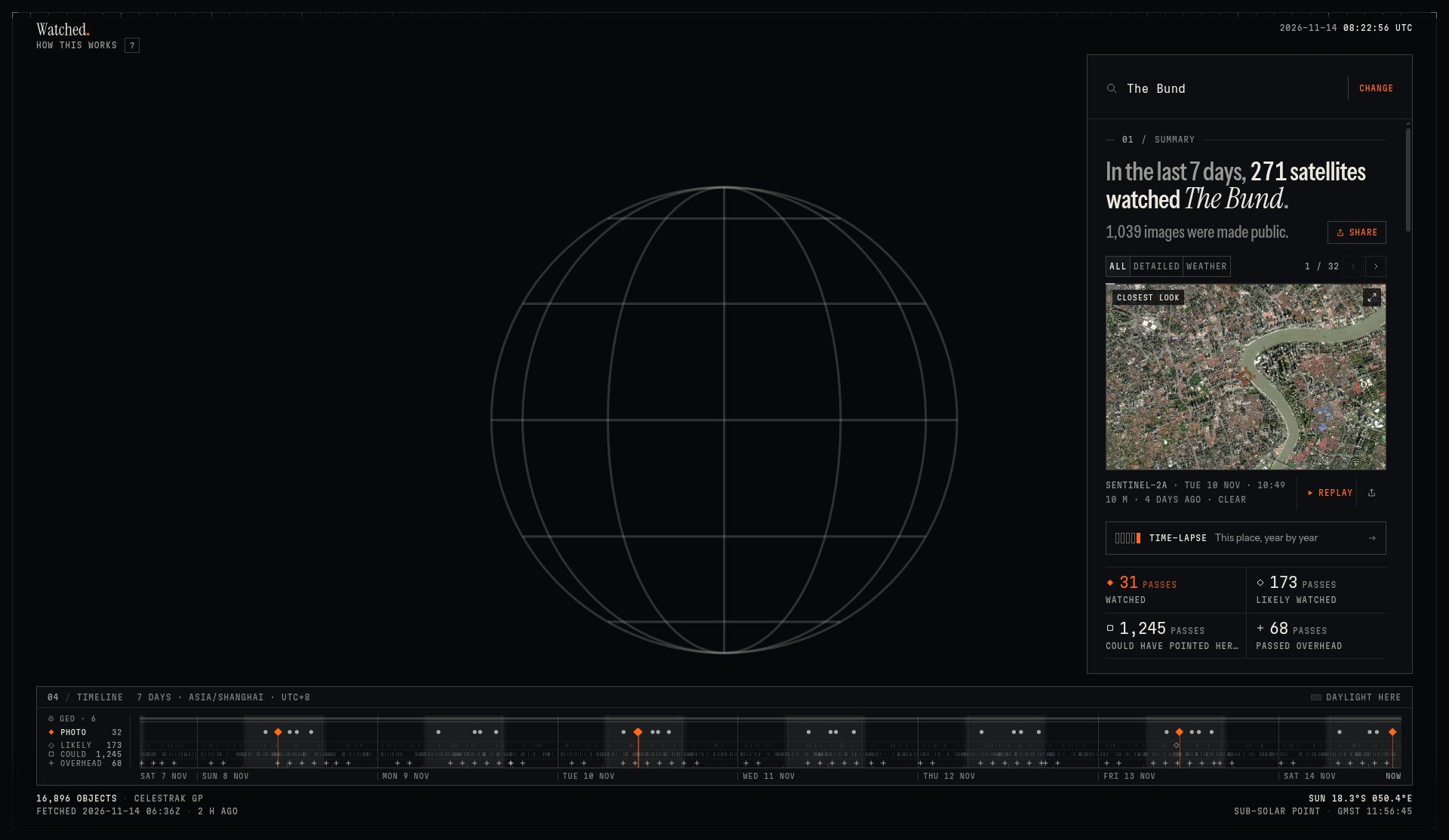
Watched.earth turns that into one query. You enter a place name or coordinates, see which satellites’ fields of view swept over that point in the past 7 days, and match already public photographs, radar, or weather imagery to the corresponding pass. On November 14, 2026 we did not sign in. We looked up the Bund in Shanghai — the historic waterfront along the Huangpu River — and we were able to open the summary and a Sentinel-2 image to check them. WebGL 2 was not enabled in the browser on this machine, so the 3D globe was unavailable, and we did not finish testing the pass replay.
Who it is for, and what to check first
It is a good fit if you want to check satellite passes and public imagery over a public place for the past week: for example, to compare a location mentioned in the news, to see roughly what a shoreline or a field looks like in a clear-sky scene, or simply to sort out that “a satellite passed over” is not the same as “there is a photo you can open.” It is not a live monitoring tool, and it will not resolve pedestrians, vehicles, or lettering on a sign.
A few easy misunderstandings are worth clearing up before you use it:
- “Watched” in the headline is a broad count. The project notes say the satellite total in the summary includes passes under every label. Only passes tagged Watched come with a matching public image.
- The public-image count in the summary also includes full-disk scenes from geostationary weather satellites. Those spacecraft take a picture every ten minutes or so, so a week can add up to more than a thousand images, while the gallery of surface scenes you can open one by one, at around 10 m resolution, is usually much smaller. Do not treat those two numbers as the same set of high-resolution photographs.
- At best, a public optical pixel is about 10 m, according to the project notes — larger than a car — and you will not recognize a person in the image. Some commercial satellites can reach about 30 cm, but their pointing and imagery are usually not public, and they only appear under labels such as “Could have pointed here.”
- Most military and intelligence satellites are not in the public orbit catalogs. The object count at the bottom of the page comes from the public CelesTrak catalog, not “everything in the sky.”
- Archives are often published a few hours to a day or two late. The newest pass may not have a photo yet.
| Item | Details (reviewed and partly tested on November 14, 2026) |
|---|---|
| Address | https://www.watched.earth |
| Repository | dev-Armaan/satellites, MIT license; author Armaan Gupta. Imagery, orbit data, and fonts each have their own terms of use. |
| Input | A place name, landmark, or coordinates. Sample points are also offered (Area 51, Central Park, Giza). There is a “Use my location” control; we did not use it this time. |
| Time range | The past 7 days (the homepage that day showed November 7–14, 2026, UTC). |
| Cost and sign-in | It works as soon as you open it; no account is required. We did not sign in this time. |
| 3D globe | Requires WebGL 2. This browser showed “3D VIEW UNAVAILABLE / WEBGL 2 IS OFF IN THIS BROWSER.” We did not test the 3D view or a complete replay. |
According to the project notes, pass calculations are done in the browser with SGP4 from public orbital elements. Public imagery is then queried from the archives of Sentinel-2, Landsat, Sentinel-1, and weather satellites. So looking up a place does not require an account, but viewing the photos still contacts those public archives — this is not a fully offline, local collection of maps. The about page also says the project does not set its own analytics cookies and does not log IP addresses; the host may set a security cookie used to tell people from bots, which the site says it does not read. The footer includes the line: “Made from public data. We didn’t take any of these photos.”
If you would rather follow the current position of flights, ships, or satellites on a 3D globe, instead of looking back at a week of public photos over one place, we have a Chinese write-up of God’s Eye View on this site. If you want to drag historical borders of China in the browser, see Chronicles of the Realm (Jiangshan Map).
How to look up a place
- Open https://www.watched.earth. You do not need to register first.
- Type a place name in the search box. When the suggestions appear, check the country and the coordinates, not just the name. After we typed “The Bund, Shanghai,” the four suggestions included The Bund in Huangpu, Shanghai (31.24°N 121.49°E), a restaurant in Canada with the same name, and hotels in Shanghai. We chose the Huangpu entry.
- Wait for the summary and the photo area on the right to finish loading. In this test, with the 3D globe unavailable, the summary, the photos, and the timeline at the bottom still appeared.
- Read the summary first, then the label counts, and only then open a photo. Do not stop at the satellite total in the first sentence.
- When you open an optical image, check the satellite name, the time, the resolution, whether it is labeled clear sky, and whether the landmarks in the frame are the place you searched for. If you need to quote or reuse the image, go by the data credit on the picture (this Sentinel-2 scene was marked Contains modified Copernicus Sentinel data 2026).
What we actually looked up: the Bund in Shanghai
The test was on November 14, 2026. We did not sign in at any point, and we did not grant location access. The query was “The Bund, Shanghai,” and we selected “The Bund / Huangpu, Shanghai, China.” The footer of the homepage at the time showed about 16,900 objects in the CelesTrak GP catalog, fetched at 2026-11-14 06:36Z.
After we selected the Bund, the summary on the right read, in the site’s own wording:
In the last 7 days, 271 satellites watched The Bund. 1,039 images were made public.
The same screen also gave four pass-count labels, and a 7-day timeline arranged in Asia/Shanghai (UTC+8), the time zone for Shanghai:
| Label (wording on the page) | Count in this query |
|---|---|
| Watched | 31 passes |
| Likely watched | 173 passes |
| Could have pointed here | 1,245 passes |
| Passed overhead | 68 passes |
| PHOTO on the timeline | 32 |
Farther down the results page a breakdown read, again in the site’s wording:
4 detailed images (Sentinel-2, Landsat, 10–30 m) · 27 daily weather mosaics (250–375 m) · 1,008 full-disc images from geostationary weather satellites (2–5 km; the newest of each is shown). 1,517 passes from 405 imaging and crewed satellites checked.
4 + 27 + 1,008 = 1,039, which matches the public-image total in the summary. In other words: 271 satellites is not 271 high-resolution photographs; the passes tagged Watched were 31; and the detailed images we could open at 10–30 m numbered only 4 this time. Another 27 were daily weather mosaics at 250–375 m, and the remaining 1,008 were full-disk weather scenes at 2–5 km (only the newest of each kind is shown). The PHOTO count on the timeline was 32. The page also states that a pass time is the moment the satellite was closest to the Bund, computed from public orbital elements (the elements in this query were fetched at 2026-11-14 06:36Z), with local time in Asia/Shanghai.
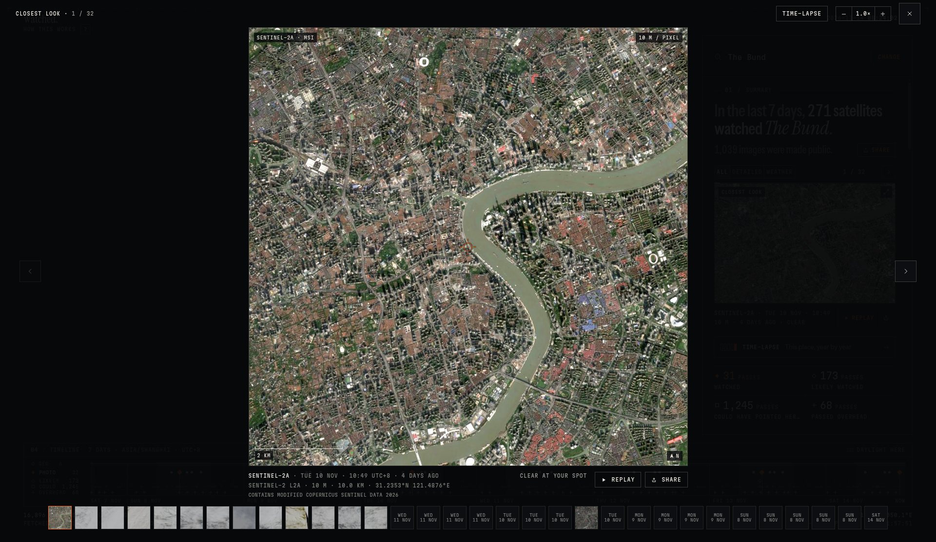
We opened the first image, marked Closest look. The page gave the following:
- Satellite: Sentinel-2A (MSI), with the product listed as Sentinel-2 L2A
- Time: November 10, 2026 (Tuesday) 10:49, UTC+8, also noted as 4 days ago
- Resolution: 10 m / pixel, with a 2.0 km scale bar on the image
- Coordinates: 31.2353°N 121.4876°E
- Weather label: Clear / Clear at your spot
- Credit line: Contains modified Copernicus Sentinel data 2026
In the frame, the bend of the Huangpu River at the Bund and the blocks on both banks were clearly visible, and they matched these coordinates. At 10 m resolution you can tell the river, the roads, and the larger clusters of buildings apart; you cannot see pedestrians. The site’s own about page also says that, at best, a pixel is about 10 m, a car occupies roughly one pixel, and you will not appear in the image.
This was the first image in the gallery. In the same row of thumbnails we also saw a NOAA-20 daily mosaic labeled November 14, 2026, 13:06, 375 m, 3 hours ago, Daily mosaic. Several other brighter or greyer thumbnails were dated November 11, 10, 9, and so on; we did not open them one by one. We did not test the pass replay or year-by-year comparison, because the browser did not have WebGL 2 at the time.
Common failures and limits
- Picking a place with the same name: the search suggestions can mix in a hotel, a restaurant, or a namesake in another country. If you pick the wrong one, a sharp photo is still not the place you wanted.
- Reading only “how many satellites watched”: that total includes Likely watched, Could have pointed here, and Passed overhead. To look at photos, go by the Watched count and the gallery.
- Treating the thousand-plus images in the summary as 10 m surface photos: a full-disk weather scene and a local Sentinel / Landsat image are not the same kind of picture.
- No WebGL 2 in the browser: the 3D globe was unavailable in this test, but that did not stop us from reading the summary and the photos. We did not fully verify whether the pass-animation replay still works in that situation.
- The newest pass has no image yet: archives lag. A mark on the timeline without a matching photo in the gallery does not necessarily mean “nothing was captured.”
- Wanting to see people, cars, or the inside of a building: public imagery cannot do that, and it should not be used that way.
- Treating these results as an official finding: pass times come from public orbital elements and may be off by several seconds. Image-matching rules follow the project notes. For research or a formal citation, go back to the original archives such as Copernicus or USGS and check there.
We did not test location permission, share cards, or year-by-year comparison, and we did not view the 3D globe or a complete replay in a browser with WebGL 2 enabled. None of those should be written up as already tested.
How it sits next to other options
| If you need to… | A better place to start |
|---|---|
| See whether a place has had public satellite imagery in the past 7 days, and which pass it was | Watched.earth (the path tested in this article) |
| Follow the current position of flights, ships, or satellites on a 3D globe | God’s Eye View (Chinese article on this site) |
| Download the original data yourself from official archives | The original Copernicus / USGS sites, not through this front end |
| Look at historical borders of China, rather than contemporary satellite photos | Chronicles of the Realm (Jiangshan Map) |
Bottom line
Watched.earth is for quickly seeing passes and already public images. It does not replace the original archives, and “a satellite passed overhead” is not the same as “a photo was taken and the detail is readable.” A reasonable expectation is: first decide whether a public image exists and whether that image is the place you meant, then decide whether to go back to the official archives for a closer check. In our Bund query, the headline totals were large; the detailed 10–30 m scenes were only four, and the Sentinel-2A frame we opened was a clear 10 m view of the river bend.


